Linking and Control Codes
Data collected in field survey data can use linking codes to enable creation of and geometry changes for linear features as the data is processed.
Control Codes provide the ability to enable special treatment of specific points to be automatically implemented during the data processing.
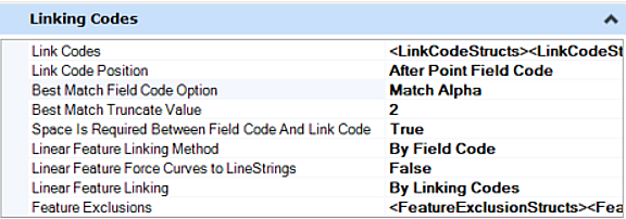
Linking codes can be Alpha or Numeric values. Control codes can only possess Alpha values.


Best Match Field Code Option
There are four best match field code options each option is explained in details below.

- Match exact: Feature Must equal an Alpha Code, only exact matches. For example if there is a Feature Definition with Alpha Code set to AP (Asphalt Pavement) and the user has points in the field with Code AP, that is a match and points and Lines will be drawn with the properties of AP Feature Definition, but if the point in the field has a Code AP1, AP2, AP3, that is not exact match and the Codes will appear in Red in the explorer pane: AP1, AP2, AP3 meaning these Feature Definitions do not exist .
- Match Start: Feature Must Start with Alpha Code. For example, if there is a Feature Definition with Alpha Code set to AP (Asphalt Pavement) and the user has points in the field with Code AP, AP1, AP2, AP3, APA, APB, APB1, APB2 the Best Match Feature Definition found will be AP and points and Lines will be drawn with the properties of AP Feature Definition .
- Match Alpha: Feature must be alpha numeric and alpha part must equal an alpha code. For example, if there is a Feature Definition with Alpha Code set to AP (Asphalt Pavement) and the user has points in the field with Codes AP, AP1, AP2, AP3, the Best Match Feature Definition found will be AP and points and Lines will be drawn with the properties of the AP Feature Definition. NOTE: APB, APB1, APB2 will not work.
- Match Truncate: Truncate Match to number of characters (feature is truncated one character at time until find matching alpha code with number of character minimum). For Example, If there is a Feature Definition name COLUMN and the point in the field has Code COLUM, with the N missing, it will be matched to the left one character at the time. This works in conjunction with "Best Match Truncate Value".
Best Match Truncate Value
Works in conjunction with "Match Truncate", if set to 2 it will truncate one character at the time until it finds matching alpha code to the left but no less than 2, for example COLUMN will be truncated as COLUM then COLU, then COL and finally CO.
Space Is Required Between Field Code And Link Code Option
Select True or False. For example: AP ST will be True, and BL*AP will be False.
Linear Feature Linking Method Option
There are three linear feature linking method options as explained below.

- By Field Code: Connects points with the same field code following the start linking code. Linear feature ends when it reaches an End control code, or another Start control code is used with the same feature code.
- By Consecutive Field Code: Connects points with the same field code but only if they are consecutive in the survey source. Start control codes are not necessary because all field codes that are consecutive will be connected). If a new point with a different field code is introduced, it will not continue to connect the linear feature. They must be shot consecutive to be linked.
- Connect All Matching Field Codes: Connects all points with the same field code in the order they are collected in the field book regardless if there are start and end control codes.
Linear Feature Force Curves To LineStrings Option
When multiple point curves are created in the fieldbook, the program will construct Bspline curves through the points. If the "Linear Feature Force Curves to Linestrings" setting is set to false, Bsplines will not be constructed, and the program will create Line String.
Linear Feature Linking
Linear feature linking methods include two options as explained below.
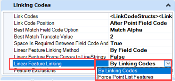
- By Linking Codes: Enable the creation of linear features from data collected in a field survey. These Linking codes can be Alpha or Numeric values. Also known as Dynamic Chains which are build from Linking codes engine running behind the scenes, The points have the same Feature, The dynamic Chains are deleted and rebuilt every time there is an edit.
- Force Point List Features: This option lets us FORCE POINT LIST type chains instead of the default dynamic chains when importing survey field data with Linking codes. Each have their advantages and disadvantages. Point List Chains or Linear features are not affected by changes in Linking Codes, the user can add a point with a different feature into the Survey Chain. The order of the points in the Point List linear feature is not dependent on the order they were collected in the field. The benefit of a point list is the ability to use the Heads-Up Tool Tip box which is not available for link code chains. With the Heads-up Tool Tip box, you have a number of editing options such as appending or breaking a linear feature.
Feature Exclusions
Used when Linear feature Linking Method is set to link linear features by consecutive field codes but want to exclude certain features. For example, the surveyor coded points with BLDG.

Every point with that code will be connected with a linear feature but you want to exclude power poles PP, so, you would set PP as a feature exclusion.